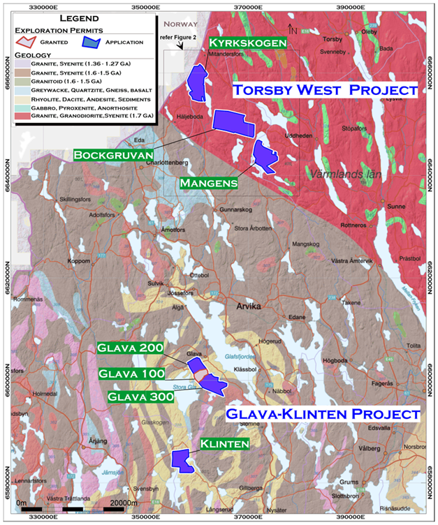
Ohmgebirge

Our Ohmgebirge Project, whilst the smallest licence held by SHP in Germany, has been identified as its priority licence area. Ohmgebirge is shallow in nature and historical drilling has demonstrated excellent sylvinite grades, within close proximity to existing shafts and infrastructure.

Ohmgebirge is located at the north-western extent of the South Harz sedimentary basin approximately 30km west of Sondershausen and 65km northwest of state capital, Erfurt.

The provided map showcases the Ohmgebirge region and its surrounding areas, illustrating various licenses and resource zones related to South Harz Potash. Here is a detailed breakdown: Ohmgebirge Region Map Details: Region Highlight: Ohmgebirge: Area: 24.8 km² JORC Probable Reserve: Sylvinite 83.1 Mt at 12.62% K₂O (10.5 Mt K₂O) Areas and Labels: Ohmgebirge Küllstedt Mühlhausen-Nohra Ebeleben Gräfentonna Legend: SHP Mining Licences (solid dark green areas) SHP Exploration Licences (patterned areas with dark green crosshatching) Inferred Resource Area (areas with green hatching) Distribution of Potash Seam (green dashed lines) City / Major Town (orange squares) Motorway (yellow lines) Federal Road (orange lines) Key Cities/Towns and Roads: Major towns like Leinefelde-Worbis, Mühlhausen, Bad Langensalza, and Sondershausen are marked. Motorways and federal roads are depicted to show connectivity. The map serves to provide a visual representation of the licensing and resource distribution for South Harz Potash in the Ohmgebirge region and its surrounding areas. Let me know if you need any further analysis or specific information from this map.

The economic potash deposit covers almost the entire Ohmgebirge mining licence. There is very little variation in mineralogy or grade across Ohmgebirge. Sylvinite is dominant and attains an average thickness of 7.2m. A 15m thick Carnallite unit is seen underlying the Sylvinite in the south-east of the licence area. The potash seams on Ohmgebirge display gentle localised undulations with no obvious dip.

Exploration commenced within the Ohmgebirge licence in 1894 for potash including cored drill holes and downhole geophysics. The area around the Ohmgebirge mining licence is a well-known potash-bearing area and is adjacent to the now closed Bischofferode and the open Bleicherode/Sollstedt Mines. After initial exploration in the early 1900s exploration recommenced on Ohmgebirge in earnest in the 1960’s. All of the later exploration drilling was conducted by the former GDR.

Four historical resource estimates have been reported on areas that cover the Ohmgebirge mining licence. Historical resource estimates are all based on the results of exploration work carried out between 1956 and 1984.

JORC Resources

SHP’s latest updated Mineral Resource Estimate JORC-table, evaluated by lead consultant MICON, Competent Person Liz de Klerk, is as follows:This table shows the Ohmgebirge Mineral Resource estimate as of March 2024, with a 5% K₂O cut-off. Here is a structured representation of the data: Ohmgebirge Mineral Resource Estimate (March 2024) Seam: Sylvinite Category: Inferred Bulk Density: 2.22 t/m³ Geological Loss: 15% Tonnage: 28 Mt K₂O: 12.52% K₂O: 3 Mt KCl: 19.64% Mg: 0.44% Na: 25.23% SO₄: 10.17% Category: Indicated Bulk Density: 2.21 t/m³ Geological Loss: 15% Tonnage: 258 Mt K₂O: 13.18% K₂O: 34 Mt KCl: 20.57% Mg: 0.80% Na: 24.18% SO₄: 11.03% Category: Ind + Inf Bulk Density: 2.21 t/m³ Geological Loss: 15% Tonnage: 286 Mt K₂O: 13.02% K₂O: 37 Mt KCl: 20.53% Mg: Not specified Na: Not specified SO₄: Not specified Seam: Carnallite Category: Inferred Bulk Density: 1.89 t/m³ Geological Loss: 15% Tonnage: 91 Mt K₂O: 9.60% K₂O: 9 Mt KCl: 15.07% Mg: Not specified Na: Not specified SO₄: Not specified


The provided map shows the Ohmgebirge region and its surroundings, including drill holes and licenses related to South Harz Potash. The map illustrates SHP mining license areas as well as historic and confirmation drill holes. It highlights two successful confirmation drill holes completed in 2022. SHP mining licenses are indicated by dark green areas. Historic drill holes are marked with green dots. Confirmation drill holes are represented by red dots. The map also displays motorways, federal roads, and country roads. Key locations such as Leinefelde, Worbis, and Mühlhausen-Nohra are marked. The scale at the bottom of the map shows distances of 0, 2, and 4 kilometers.

Ongoing Project Evaluation

In recent years, two exploratory drillings have already been conducted in the Ohmgebirge. A scoping study and a pre-feasibility study (PFS) have also been completed. Additionally, spatial planning approval has been positively granted by the responsible authority.

Ohmgebirge PFS evidences world-class potash development at South Harz Project – FIND OUT MORE.


Subscribe to our email newsletter to receive the latest news and updates
  • This field is for validation purposes and should be left unchanged.